In Surfer, the Measure tool's length and area outputs are directly tied to your map's X and Y coordinate units. This means if your map's coordinates are in meters, your measurements will be shown in meters and square meters. For maps that have a projected coordinate system assigned (not Lat/Long), Surfer allows you to customize these display units.
Projected coordinate system (i.e. not Lat/Long)
If the map has a projected coordinate system assigned to it (i.e. not Lat/Long), you can change the units displayed in the Measure dialog by clicking Options | Units. Select the desired units and click OK. The measure results are immediately updated in the new units.
Click the Options button,
and click Units to set the units of the measure.
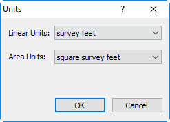
In the Units dialog, select the desired linear and area
units and click OK. The units in the Measure dialog are updated.
Geographic coordinate system or Undefined coordinate system
If your map does not have a projection defined, or it is in lat/long, then the units cannot be changed in the Measure dialog. To change the units, the units of the map can be changed by changing the coordinate system. Once the coordinate system has been changed, then the units in the Measure dialog will update the next time the command is used. It is useful to change the coordinates of the map if the desired length and area units are different than the map units.
For example, to change a map in lat/long to units of meters, follow these steps:
- In the Contents window select the Map object.
- In the Properties window select the Coordinate System tab.
- Click Change next to Coordinate System.
- In the Assign Coordinate System dialog, select the appropriate coordinate system. To convert the map units to meters, the coordinate system can be converted to a UTM coordinate system. The UTM coordinate systems can be found by navigating to Predefined | Projected Systems | UTM.
- Click OK. The map has been converted to UTM, which is in meters.
- Now if you click Map Tools | Map Tools | Measure and measure a line or area, the results will be in units of meters.
Key Resources
Beyond changing the Map Tools | Map Tools | Measure units, Surfer provides robust tools for managing all aspects of your map's units. To help you address various unit-related challenges and achieve full control over your data's presentation, we've compiled these key resources:
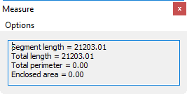
- Surfer Help > Measure | Surfer's Measure command calculates the planar distance and area of a drawn line or polygon on a map, displaying results in map units in the Measure dialog, without using Z values or accounting for Earth's curvature.
Changing units
- Change the projected coordinate systems units in Surfer (Feet, Meters, Kilometers) | Achieve precise and consistent unit representation in your Surfer projects by learning how to change the projection units of a coordinate system.
- Change the XY units on a map in Surfer | Create a map from a grid or data file with XY values in one unit (e.g. meters) and then convert them so the map is displayed in another unit (e.g. feet).
- Change units of the map scale bar in Surfer | The scale bar for a map in is map units by default. This can be changed, but how to do so depends on whether the map is in linear units (e.g. meters or feet), or spherical units (e.g. lat/lon degrees).
Coordinate systems for map vs layer
- Understanding Map vs. Layer Coordinate Systems
- Display and Multi-System Workflows
- General Resources & Troubleshooting
Comments
Please sign in to leave a comment.