The XY coordinates of your grid can be converted from one linear unit to another, such as, feet to meters using Grids | Edit | Project. This applies if your grid has a predefined coordinate system or not.
To do this, follow these steps:
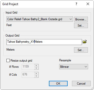
- Click Grids | Edit | Project.
- In the Grid Project dialog, in the Input Grid section, select the grid file from the drop down, or click Browse, select the grid file and click Open.
- If the grid file has a predefined coordinate system, it will be displayed under the grid file and you can skip this step. If not, it will say Unreferenced local system.
- If it says Unreferenced local system, click the Set button.
- In the Assign Coordinate System dialog, click the Modify button.
- In the Define Unreferenced Coordinate System dialog, under Linear Units, click <unknown> to the right of Name, and select the current coordinate units (e.g. Feet). You might want to change the Name at the top of the dialog ("Feet"). Click OK.
- In the Assign Coordinate System dialog, your coordinate system is selected under Custom. Click Add to Favorites to keep this for the future. Click OK.
- Back in the Grid Project dialog, in the Output Grid section, give the file a name.
- For the output grid, click the Set button.
- In the Assign Coordinate System dialog, click the Modify button.
- In the Define Unreferenced Coordinate System dialog, under Linear Units, click <unknown> to the right of Name, and select the coordinate units you want the file to be in (e.g. Meters). You might want to change the Name at the top of the dialog ("Meters"). Click OK.
- In the Assign Coordinate System dialog, your coordinate system is selected under Custom. Click Add to Favorites to keep this for the future. Click OK.
The grid has been converted and can now be used for other purposes (e.g. create maps or other grid processing operations)
Use Grid Project to convert the XY coordinates of a grid file from one linear units to another
Updated November, 2021
Comments
Please sign in to leave a comment.