- Click File | Options.
- In the navigation tree on the left, click User Interface.
- In the Map Coordinate Format section on the right, expand either Linear coordinates if you're using projected coordinates or Spherical coordinates (degrees) if you're using lat/long coordinates.
- Increase the Significant figures or Decimal digits value to the number of significant figures you want to see in your status bar.
- Click OK.
The status bar should now display the coordinates with the number of significant figures you want to see.
Select which layer to display XYZ coordinates in the Surfer status bar
Surfer will not track the coordinates of invisible map layers (map layers unchecked in the Contents window). For example, if you have two separate maps on top of each other in the plot window, then the coordinates in the status bar would be for the top-most layer in the top most map.
By default, Surfer will track the XYZ coordinates of the top-most layer, the Contours layer.
The behavior can be changed from tracking the top-most map or layer, to tracking a selected layer by clicking File | Options. On the General page, change Track map coordinates of from Topmost map/layer (the default) to Selected map/layer. Click OK and the status bar will report the XYZ coordinates of the selected layer. If no layer is selected, then no XYZ coordinates will be reported in the status bar.
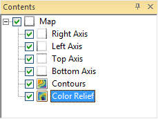
Set Track map coordinates of to Selected map/layer, and then select the Color Relief layer to track the XYZ coordinates of the Color Relief layer in the status bar.
Updated October, 2021
Comments
Please sign in to leave a comment.